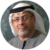
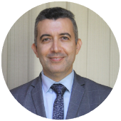
Dr. Jauad El Kharraz is the Executive Director of the Regional Center for Renewable Energy and Energy Efficiency (RCREEE), an intergovernmental organization with diplomatic status based in Cairo with 17 Arab countries onboard. Dr. El Kharraz took his office on October 2021 bringing over 20 years of experience in various sustainable energy fields including energy policies, wind and solar technologies, and green hydrogen in addition to water management, desalination, water-energy-food-climate nexus, climate change, and environment.
As the Executive Director, Dr. El Kharraz undertakes the strategic management of RCREEE. He leads RCREEE Secretariat in implementing its strategy aiming to enable and increase the adoption of renewable energies and energy efficiency practices in RCREEE 17 member states. With the region’s great potential, rapid sustainable energy market changes, Dr. El Kharraz is entrusted with tailoring innovative initiatives to deepen Arab-Arab cooperation in sustainable energy fields & to boost our member states’ efforts towards energy transition.
Prior to joining RCREEE, Dr. El Kharraz held the position of Director of Research at the Middle East Desalination Research Center in Oman (2015-2020). Previously, he served as a senior expert, advisor, and evaluator for several international institutions (e.g., European Commission, UN-ESCWA, PRIMA Foundation, EU-GCC Clean Energy Technology Network, KAS-REMENA, Ocean Oasis, COMSTECH Scientific Advisory Council, ENSUS/UM6P University, EMME-CCI Task Force/Cyprus Institute, “French Ministry of Higher Education, Research and Innovation”) and member of board of the European Desalination Society, AgreeMed and WEFE4Med Nexus projects and Jovesolides Association (Spain). He is also member of the International Desalination Association, the Mediterranean Water Institute, and Oman Energy Majlis.
He brings over 20 years of experience in various sustainability fields including energy and water policies, desalination, water-energy-food nexus, green hydrogen, climate change. Dr. El Kharraz sustainability career officially started in 1998 as a researcher at the Global Change Unit -University of Valencia. Through his journey, he coordinated, prepared, and contributed to an important portfolio of international programs/projects of millions of euros such as FP5-FP7, H2020, ENPI CBC Med, INCO MED, INCO NGOs, SMAP, LIFE, PRIMA. He carried out projects for national and international donors such as GIZ, SIDA, IsDB, TRC/Oman and USAID apart from private sector companies.
Dr. El Kharraz is a founding member of Nice hub (France) – Global Shapers Community (World Economic Forum), aiming to push young talents from Nice city to develop projects of development for their local community.
He chaired and contributed to the development of an important number of scientific papers, policy briefs, policies, training & mentorship activities, lectures, awards ceremonies, and events (e.g., World Economic Forum, World Water Forum, World Science Forum, World Urban Forum, Abu Dhabi Sustainability Week, MENA Europe Future Energy Dialogue, World Hydrogen Summit, Planetary Security Initiative, Berlin Energy Transition Dialogue Conference, International Higher Education Conference, COP26, COP27, etc.) in more than 55 countries.
Dr. El Kharraz is a national of Morocco and France, and a graduate of the University of Abdelmalek Essaadi. Dr. El Kharraz obtained his MSc and PhD degrees in Physics from the Department of Earth Physics and Thermodynamics, University of Valencia, Spain, and a diploma in enterprises management and strategies from SKEMA Business School, France. He is a fluent French, Arabic, Spanish and English speaker.